IN BC'S GOLDEN TRIANGLEMidas Property
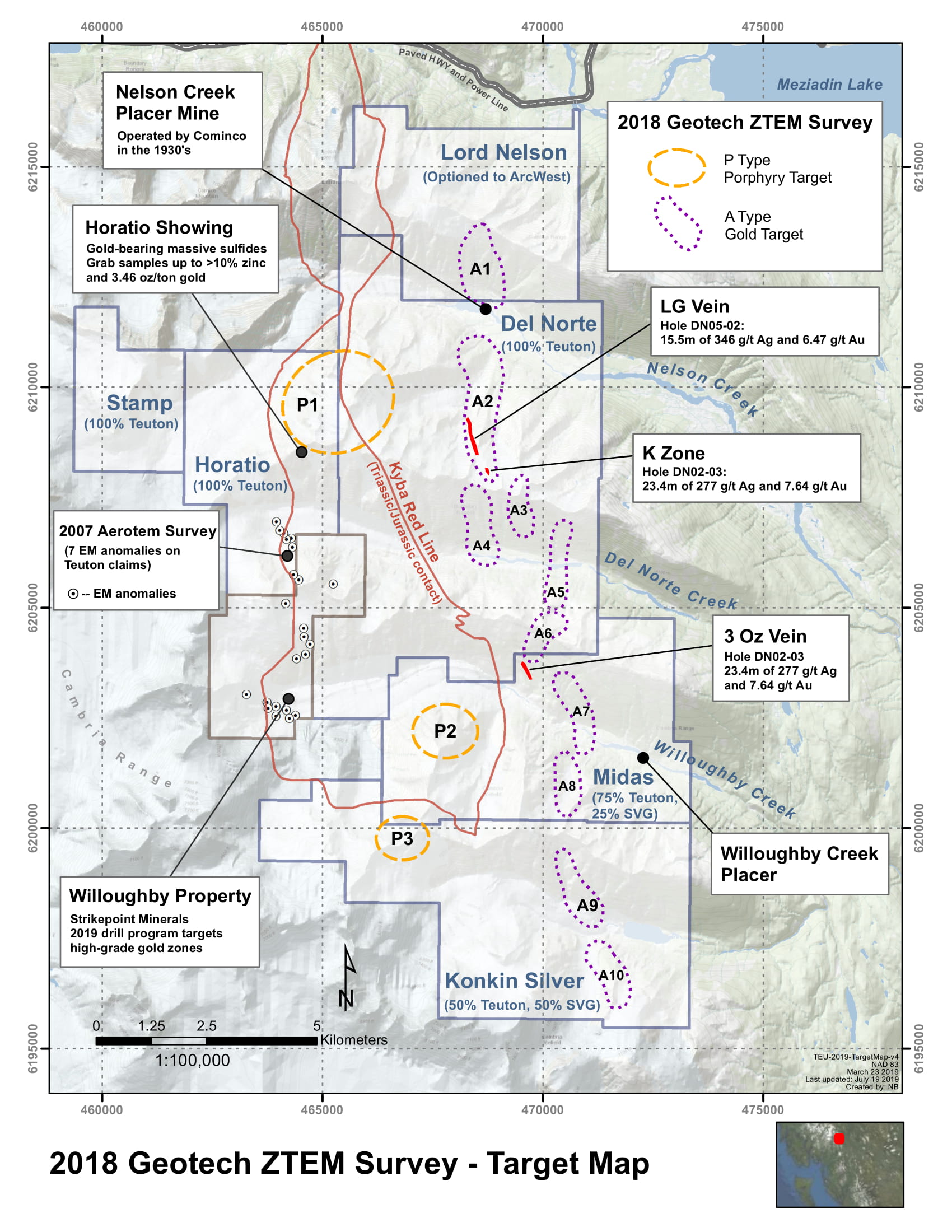
The Midas property lies along a regional, northerly trending contact zone between volcanic and sedimentary rocks known to be associated with precious metal mineralization (especially on the Del Norte property of Teuton Resources adjoining due north). Willoughby Creek, a gold placer stream, cuts through the northern extent of the property. Drilling in 2005 on the the “3 Ounce” zone has returned values running to 47.7m of 1.77 g/t gold and 10.4 g/t silver.
RECENT EXPLORATIONWhat we've been working on
A Geotech ZTEM airborne survey was flown over the property in 2018 disclosing two gold target areas on the Midas property—the A7 and A8—and also a porphyry target, the P2. Geotech described the targets as follows:
“A8” - This target is located in the south-eastern part of the block and lies at the contact volcanics/sediments of the Hazelton Group. It is stretching roughly in the NS direction over a distance of ≈ 1 km. It has an estimated resistivity value of < 30 ohm-m at depth of 300m, coincides with a strong Aerotem conductor and occurs within a zone of magnetic low. This target is controlled by a NE striking fault and it is bound to north and south by two NW striking faults. It may represent a link to a tension fault generated by the NW striking fault system.
“A9” - This target is located in the south-eastern part of the block and lies within the Konkin Silver mineralized zone. It lies within the Hazelton Group volcanics and appears to be structurally controlled by a NNW striking fault. It is stretching roughly in the NNW direction over a distance of ≈ 2 km along an inferred fault zone. It has an estimated resistivity value of < 30 ohm-m at depth of 300m and coincides with a strong Aerotem conductor.
“P2” - This circular feature is located in the south-central area of the block. It exhibits a resistive core of ≈ 1 km in diameter (at depth of 300m) surrounded by a moderately conductive ring typical to mineralized porphyry stockwork. Its core is strongly magnetic.
Property Ownership
Ownership of the Midas property is presently 25% Silver Grail and 75% Teuton Resources Corp. It is located approximately 17 miles east of Stewart, British Columbia, in the upper drainage area of the White River system. Nearest road access is about five miles to the east, at the western end of a network of logging roads connecting to Highway 37.
Property Location